Melissa

MelissaWeekly.news · Local news for a growing North Texas hometown.

Back to Weather

5-day forecast / Melissa, TX

MondaySunny then Slight Chance Showers And Thunderstorms94° / 73° 18%
TuesdaySunny then Slight Chance Showers And Thunderstorms93° / 75° 24%
WednesdaySunny95° / 79° 3%
ThursdaySunny98° / 79° 2%
FridaySunny97° / 79° 2%

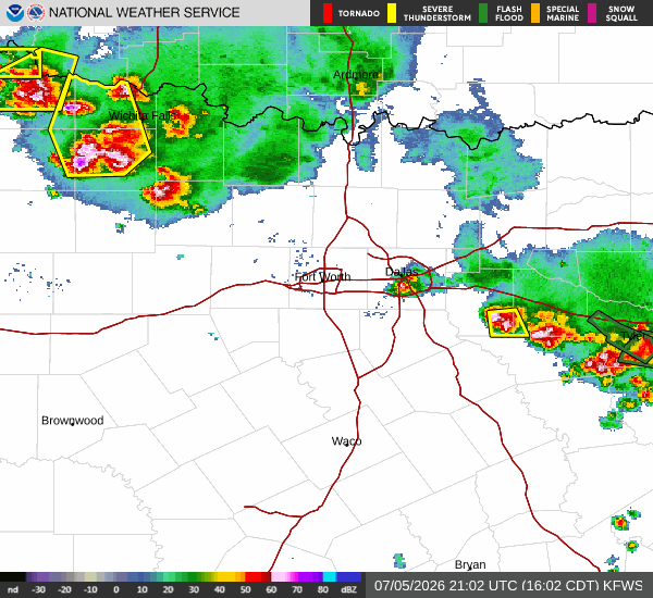
Severe Thunderstorm Watch and Dangerous Heat Impact Melissa - Jul 5, 4 PM

Melissa weather, updated every four hours — local forecasts you can trust.

A Severe Thunderstorm Watch is active for Melissa, TX, alongside oppressive heat with a feels-like temperature of 103F. Residents should monitor conditions closely today.

Arlen Iverson

July 5, 20262 min read

National Weather Service radar for North Texas (KFWS)

As of Jul 5, 4 PM local time.

Active Alerts and Current Conditions

A Severe Thunderstorm Watch is currently in effect for Melissa, Texas, issued by the National Weather Service in Fort Worth. This alert remains active until 10:00PM CDT today, signaling an environment where severe weather is possible. Alongside this meteorological threat, residents are facing dangerous heat conditions. Current readings show an air temperature of 90F, but the combination of humidity and heat has pushed the feels-like temperature to 103F. The atmosphere is oppressively humid, with a dew point of 77F and relative humidity at 67%. Winds are light, blowing from the southeast at 3 mph with gusts up to 3 mph, under a clear sky.

Forecast for Today and Tomorrow

Today, the chance of showers and thunderstorms remains, with a 37% probability of precipitation. The high will reach near 97F, though temperatures may dip slightly to around 94F in the afternoon. Heat index values are expected to climb as high as 103F. Rainfall amounts between a tenth and a quarter of an inch are possible. Tonight, conditions will shift to mostly cloudy skies with a low near 75F. There is a chance for showers and thunderstorms before 1am, with a 30% chance of precipitation. Heat index values will remain elevated, reaching up to 99F. Winds will shift to the east northeast at around 5 mph.

Tomorrow, the severe weather threat diminishes significantly. The sky will be mostly sunny with a high near 95F. Despite the clearing skies, the heat will persist, with heat index values as high as 102F. Winds will continue from the east northeast at approximately 5 mph. The chance of precipitation drops to 11%. Tomorrow night, skies will clear to mostly clear with a low around 74F. A slight chance of showers and thunderstorms exists between 7pm and 1am, with a 20% chance of precipitation. Heat index values will stay near 99F.
Safety Reminders

Given the active severe weather watch and extreme heat, please stay informed through local news and weather apps. Hydrate frequently and limit midday exertion to avoid heat-related illness. If severe weather approaches, seek sturdy shelter immediately. Check on neighbors and vulnerable community members who may need assistance during these hazardous conditions.

National Weather Service radar for North Texas (KFWS)

Sources

https://radar.weather.gov

https://api.weather.gov

https://open-meteo.com

Share

Arlen Iverson

Arlen Iverson covers weather, storms, and seasonal life around Melissa.

Related Stories

More in Sport